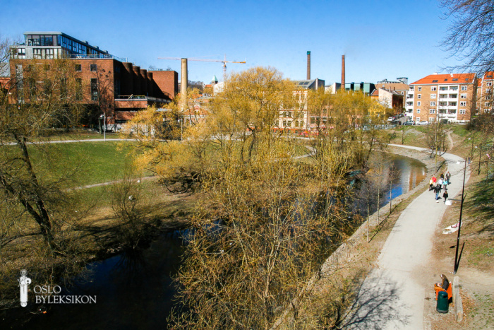
Aker river
Denne artikkelen omtaler et sted
Åpne i Oslo bykartAker river (Akerselva), The, Oslo’s largest and most important river. Back in the time of the sagas it was called Frysja, later also O (cf. Lillo, Storo), a dialect form of Å, which means ‘river’, usually in Danish. It is reasonable to assume that for a while the river was simply referred to as åen (= the river), since many people still call it ‘ælva’ (pronounced with Dark L).
Akerselva runs from Maridalsvannet (149 metres asl.) to Bjørvika, a distance of 9.9 km. It constitutes the lower section of Nordmarksvassdraget, a watercourse that has its uppermost source in a small tarn in Puttmyrene in Jevnaker, having a total length of 47 km to Bjørvika.
The course of Akerselva from Maridalsvannet to Oslofjorden cuts across the southwest-northeast line of strike in the underlying Cambro-Silurian alluvia in the bedrock, which has resulted in a watercourse with many twists and turns and about 20 waterfalls. This means that the river has enabled useful power to be produced. There has been mill operation along the river since the Middle Ages and sawmill operation since the introduction of the head saw in the 16th century – and power from the river has in particular been a precondition for the growth of Oslo as an industrial city in the latter half of the 19th century.
Akerselva runs through a culvert from Vaterlandsparken to Operaen. In the former industrial area of Nydalen factory buildings also lie above the river. All the smaller streams that join Akerselva are now covered.
Akerselva was a good salmon and trout river in the medieval period and earlier, and as late as 1724 fishing for pearl mussels took place in the river. It was formerly of considerable worth to have ratified fishing rights in the river. Modern industrialisation from the 1840s onwards, however, ruined the fishing, and the first municipal sewer was also led directly out into the river. The environmental situation improved with the building of separating sewers and purification plants.
Industry along Akerselva
Water power from Akerselva was exploited early on. The first known flour mill beside the river lay at Sandaker (1341). With logging and sawmills in the 17th century, the city entered its first ‘pre-capitalistic’ era. Citizens made fortunes based on forestry, sawmills, the export of timber and speculation in the government’s sale of crown land. An important precondition was Akerselva as a waterway and source of power for floating and saw mills.The manufacture of paper was part of the earliest industrial activity along the river.
In the 1840s, industrial development started, gradually replacing most of the earlier industrial activity. Initially, it was mainly the waterfalls that attracted companies, with waterwheels and turbines in the river being used as sources of power. The ‘new’ industry along the river was mainly workshop and textile industry.
As technological progress made it possible to transport electric power over longer distances, industrial enterprises were no longer dependent on being situated close to the source of power. At the same time, some of the industrial businesses operating along the river were exposed to competition from the international market. The textile industry in particular was badly hit, but also a number of the other traditional industries were shifted in the interwar and postwar years from Akerselva, or closed down. By the 2010s, practically none of the major old industrial concerns were still operating along the river. There was only still remaining industrial activity at Spigerverket and Bjølsen Valsemølle.
Elvepark
The idea of making use of the banks of the Akerselva as a green belt through the city was proposed by Major Jacob Høe in 1915, as a countermove against plans to canalise and cover over sections of the river. At the opening of Sannerbrua in 1917, the municipal mayor, Carl Jeppesen, spoke these famous words: ‘May Akerselven become a broad smile and not an ugly furrow in the face of the capital.’ The park plan for the section between Nybrua and Ankerbrua was approved in 1918; later, planning and the establishing of the green belt has been carried out in stages, with the stretch between Ankerbrua and Østre Elvebakke just about completed in time for the unveiling of Dyre Vaas’ sculptural decorations at Ankerbrua in 1937. The green artery was originally planned to go as far as the old city boundary at Christiania Spigerverk, but after the merging of city with Aker, the plan now included the entire section up to Maridalsvannet. Much of the work was carried out in the 1960s and 1970s. Myraløkka was developed in the 1967-78 period. Work around the bathing pool at Brekke took place in 1967-77. And the stretch from Vaterland to Nybrua was developed in 1974-82. Practically the whole stretch has been completed as a green belt, with only a small area around Bjølsen roller mill now closed to the public. This transformation of the river banks, combined with an improvement in the quality of the water, has created a highly popular river park area. Bathing is possible at Brekkedammen, Stilla and in Nydalsdammen. In various contexts, Akerselva has been presented as a dividing line between east and west in the city. This is somewhat imprecise and is now mostly a common expression that has little actual content.


